Introduction
The former railway of the Dolomites walk is one of the most popular in Cortina, both in summer and winter. The route follows the former railway track that connected "Dobbiaco" to "Calalzo," crossing Cortina from north to south. Let's discover together this relaxing walk in all its variations!

The Former Railway Path
The path of the former railway is a road both for cycling and walking but closed to motor vehicles, which crosses Cortina for its entire length. It is a walk suitable for everyone, on a paved and illuminated road with a negligible difference in altitude for its entire length and various access points throughout the town.

Given its super central location, it is used by many people both as a tourist walk and to move around the town. In addition to pedestrians, the former railway of the Dolomites is also used by amateur cyclists, including those who ride the "Lunga Via delle Dolomiti" or the "Monaco Venezia," two of the most scenic bicycle routes in the whole Alps.
... the former railway of the Dolomites is carefully cared for...
Along the path of the former railway, you will find several benches, as well as three fountains where you can drink pure alpine water. This route is of great importance to the local community; for this reason it is carefully cared for: in summer, the grass along the edges of the roadway is kept short, while in winter the snow is regularly removed.

To make the article more readable, we divided it into three main chapters. The first describes the south direction, towards "Zuel" and, if you want to proceed, the town of "San Vito di Cadore," and even further:
The second chapter describes the opposite direction, north, exiting at the height of "Fiames," to proceed to the parking lot of the "Dolomiti d'Ampezzo" Nature Park, the starting point of many hikes. From here you can also reach the parking lot for "Malga Ra Stua" in about thirty minutes. We will explain all these paths in the following chapter:
The last chapter describes the north direction too, but proceeding along the former railway until you reach "Ospitale" and "Cimabanche," at the border between the "Veneto" and "Alto Adige" regions:
 Help us stay ad-free with a small offer.Donate now!
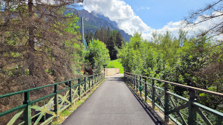
Towards Zuel
Map

Path of the Walk
In this chapter, we describe the walk of the former railway in a south direction; our destination is the former railway gatehouse, in the locality of "Zuel," starting from the center of Cortina d'Ampezzo. This walk can be done during the whole year, as is regularly maintained also in winter.
This is a walk suitable for everyone, even the elderly and small children, on a paved and illuminated road, with a negligible height gain along its entire length. This section of the former Dolomites railway has numerous benches for resting, as well as two fountains with drinking water.
We decided to start the walk from the town center, at the feet of the bell tower. From here you have to go up the road perpendicular to "Corso Italia," called "via 29 Maggio." At the end of the climb, cross the road and keep to the right until you reach the "Faloria" cableway.

Once you reach the "Faloria" cableway, proceed along the iron bridge over the state road. From here, you will have a new point of view on the "Boite" Stream and the Cortina Ring Road.

The walk continues flat, crossing "via Menardi" and turning gently to the right. Here you can see the first fountain, on your left, exactly here.

Continuing along the former railway, you'll cross "Via Faloria," and then you'll walk along a perfectly straight path. At the end of the straight road, a couple of curves will indicate the entrance into the locality of "Cojana," in the district of "Zuel."
Here you could consider a detour, going down to the right, towards the "Bar Toto," a really nice bar where you can stop to drink something or eat a really good sandwich in front of a breathtaking panorama.

Proceeding along the former Dolomites railway, you will see the second fountain and then a traffic light, which will allow you to safely cross the road. From here the road proceeds immersed in the green towards the locality of "Zuel" and the Olympic Ski Jumping trampoline "Italia."

The walk continues along the wide meadows of "Pezié," where you can see an amazing panorama of Mount Faloria, Mount Antelao, and Mount Five Towers. Up to this point, the walk should have taken you about thirty minutes.

After a while, on your left, you will see the Rosapetra Spa Resort. It is a large hotel with a swimming pool and a solarium terrace overlooking the Tofane. There you have officially entered the village of "Zuel." From here, keep walking straight on the pedestrian road, following the signs for the cycle and pedestrian path. You will cross the municipal road twice before seeing the "Zuel" former railway gatehouse appear in the distance.

The Zuel railway gatehouse is a former stop of the Dolomites Railway. It was inaugurated in 1921 and remained in operation until 1964. If you want more information about the Dolomites train, we talk about it further down in the chapter "history of the railway."

The walk up to this point has been three and a half kilometers, or two miles, and should have taken you about an hour. To return to the center of Cortina, you can retrace your steps or consider taking Bus No. 2. In "Zuel," there are two bus stops: the first is in the center, but the one you should prefer is on the state road.
If you want to walk a little further, you have several options. The most obvious is to continue south; you can follow the "Lunga Via delle Dolomiti" as far as you want; "San Vito di Cadore," the next town, is about eight kilometers, or five miles, away, but the former railway continues well beyond.
... the "Lunga Via delle Dolomiti" continues until "Calalzo di Cadore..."
To avoid walking on the state road, when the protections end, we recommend you go down to the right, towards "Pian da Lago." Once you reach the crossroads turn left, following the signs of the "Lunga Via delle Dolomiti."
If you prefer walking in the woods, you may consider taking a visit to Lake Pianozes. It is a very beautiful walk, a little more demanding, that will take you about an hour and a half. We have talked about it in depth on another page, which you can see below:
 Help us stay ad-free with a small offer.Donate now!
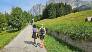
Towards Fiames
Map

Path of the Walk
In this chapter, we describe the walk of the former railway in a north direction; we will take the exit towards "Fiames," then continue towards the "Pian de Loa" information point and, subsequently, to the "Sant'Uberto" parking area.
The walk is suitable for everyone, even elderly people and small children. It goes on a partially asphalted and illuminated road, which does not have particular differences in height, at least up to Fiames. The first section is asphalted and has numerous benches for resting, a fountain with drinkable water, and is accessible both in summer and winter. The second part, on gravel road, can only be done in summer, as in winter it's converted to a cross-country ski slope.
This walk starts in the center of Cortina, exactly in front of the "Hotel Ciasa Lorenzi," which is located exactly at the entrance of the former Dolomites Railway.

Following the signs for the "Ciclabile delle Dolomiti," take the cycle and pedestrian path towards "Ospitale" and "Cimabanche." The road continues gently and always well signposted through "Cianderies," a locality where some of the most prestigious houses in Cortina are located.

After crossing the road, near the locality called "Verocai," the houses will begin to thin out, leaving space for the large meadows of "Cademai," the name of another locality, in the area called "Chiave."

You will go through an underpass, and a little further on you will see, on your right, the fountain of the "Codivilla." The name comes from its position since it's located near the Cortina ospital, which is called "Codivilla." Here ends the jurisdiction of the Municipality of Cortina, so from this point on there will no longer be night lighting, and snow removal will not be guaranteed. The walk, for now, should have taken you about thirty minutes, with a distance of one and a half kilometers, almost one mile.

You will see the last houses as the forest begins to make its way. After about a kilometer, you will find a barrier that blocks the passage of cars. This will also mark the transition from the asphalt surface to a gravel road.

Shortly after crossing the barrier, a crossroads will make you choose if going down towards "Fiames" or proceeding towards "Cimabanche." In this chapter we will head left, toward "Fiames," while we will see the road towards "Ospitale" and "Cimabanche" in the next chapter.

Take the road to the left, following the signs of Path 211, towards "Fiames" and "Pian de ra Spines," it is a pleasant woodland path alongside the state road.

At the next crossroads, keep left again, following the signs for "Lago Ghedina" and "Cianderou." This is one of some roads that lead to "Fiames" from the former railway; we have opted for this one as it allows you to reach other nice hikes, which we'll describe to you as you continue reading.

Go past the barrier that blocks access to the vehicles and cross the state road, paying close attention to the cars coming at high speed. Head towards the "Camping Olimpia," then take the access road to the camping.

Just before reaching the bridge over the "Boite" Stream, take the path on the right, the one marked by the sign "Pian de ra Sia," or you can follow the signs to the "Bar Albergo Fiames."

The trail continues in the woods, then crosses a gravel parking lot, and finally re-enters the woods to reach the "Bar Hotel Fiames." From this gravel square depart the shuttles to "Malga Ra Stua," a nice farmhouse immersed in the green. The walk up to the hotel should have taken you about an hour and a half, for a distance of almost five kilometers, or three miles.
If you are tired you can safely stop here, the "Bar Hotel Fiames" is a pleasant place to eat or drink something in a convivial atmosphere. We recommend, in low season, to call to check the actual opening of the place.

Behind the "Bar Hotel Fiames," you can see an asphalt square, which is also the stop of Bus n°2. This is a good option to get back to the center if you don't want to walk anymore.
If you still feel like walking, you could return to Cortina following an alternative route. Do you remember the bridge near the camping site? There starts a very beautiful walk from "Fiames" to the locality of "Cadin di Sopra." If you want more information, we describe it on the page below:

If you want to keep walking within the valley, there are several interesting destinations north of "Fiames."
Head behind the hotel, where you will find a metal bar and a sign "Bosco dell'impero" Q. 1295 m, "Felizon," "Pian de Ra Spines," and "Val di Fanes." From here, you can take the wide and flat pedestrian path that goes into the woods.

You will walk alongside the runway of the former airport for about one kilometer, or a third of a mile, until you reach the banks of the "Boite" Stream, which will be on your left for a few hundred meters, before entering the woods again.

During the hottest days, many people use these banks to sunbathe and organize picnics, you could take inspiration.
The walk ends at the free parking lot of the Ampezzo Dolomites Natural Park; it took you two kilometers, or one mile and a third, all flat. Here you can also find the Dolomites Park information point, a small wooden house.

Here is the starting point of various hikes, such as the one to "Pian de ra Spines," which you could consider for the way back. This is a very beautiful and relaxing walk that will take you back to the bridge near Camping Olimpia via the other side of the "Boite" Stream. We describe it on the page below:

The road continues beyond the information house, towards the "Sant'Uberto" parking lot. Once you reach the sign indicating "Ponte Felizon," keep right, following the signs towards "Val di Fanes."

Follow the asphalt road for about a kilometer, until you reach the crossroads indicated by the sign "Laštié" Q. 1350 m. At this point you will have to leave the asphalt road and follow the gravel road, which goes up towards "Sant'Uberto."

The road continues quite steep for about five hundred meters, or a third of a mile, until you see the state road appear above you. Continue a few more meters until you reach the sign "Sant'Uberto" Q. 1411 m. Finally, turn right, following the signs for "Malga Ra Stua" and "Val Salata," to reach the Parking Sant'Uberto.

This is not a particularly interesting destination itself, but it is the starting point to reach "Ra Stua" and the ruins of the Castle of "Podestagno." The first is a longer hike if you came from the town center; consider it only if you are avid walkers, but the second could be ideal if you feel like walking another hour. We talk about it on the next page:

From the ruins of the "Castello di Podestagno," it is possible to reach the former railway again, continuing towards "Ospitale" and "Cimabanche," but we will talk about this in the next chapter.
Help us stay ad-free with a small offer.Donate now!
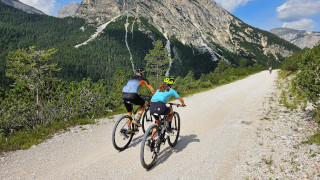
Towards Ospitale
Map
Path of the Walk
Also in this chapter, we describe the walk of the former railway in a north direction, but keep walking along the main road. Our first destination is the locality of "Ospitale," then continuing to "Cimabanche." The starting point is the center of Cortina d'Ampezzo.
It is a definitely simple walk, but quite long, on a gravel road and without any particular changes in altitude. It is also particularly suitable for being tackled by bicycle, as long as it is a mountain bike or a gravel bike.
The walk, in its entirety, is not recommended for elderly people and small children, but it's always possible to do it only partially. The first section, up to the locality of the "Codivilla," is accessible all year round, while the second part can only be walked in summer, as in winter it is crossed by cross-country ski trails. The first section of the former railway is equipped with numerous benches for resting, as well as a fountain with drinking water.
The starting point of this walk is the "Hotel Ciasa Lorenzi," which is located at the entrance to the former railway road.
Follow the signs for the localities of "Ospitale" and "Cimabanche" along the cycle and pedestrian path known as "Ciclabile delle Dolomiti." The path is always well marked; pay attention only to the points where the municipal roads cross the former railway; in any case, you must always go straight. As you walk, you will leave the central area of the town behind you, and the houses will be less and less.
After about half an hour of walking, on your right, you will see the Codivilla's fountain; its weird name comes from the hospital above, which is called "Codivilla Putti." Here ends the section under the jurisdiction of the Municipality of Cortina; from this point on there will no longer be night lighting, and snow removal will not be guaranteed.
The former railway walk enters the woods for about a kilometer, or two thirds of a mile, when a barrier blocks the passage of cars. This point will also mark the passage from asphalt to gravel road. After passing it, continue to the right, following the signs for "Ospitale" and "Cimabanche." The road continues with a gentle and constant slope.
Along the former railway there are still the railway toll booths where the stops were located, such as the one at "Fiames," unfortunately all of them are inaccessible and uninhabited.

When the forest begins to thin out, you will see a splendid panorama of "Fiames," the Mount "Col Rosà," and the Mount "Pomagagnon," as well as a privileged view of the hill where the "Podestagno" Castle overlooked the valley below.

Once returned into the woods, some concrete ruins will announce the entrance into the first of the two tunnels, the longest and artificially lit one. A headlamp is not necessary, but be careful of the glare; you might not see a bicycle coming at speed.

Once you have passed the tunnel, a high wooden bridge will make you cross the stream named "Ru Felizón." The protections are very safe and generous; in fact, they take away a bit of the atmosphere from the bridge. If you suffer from vertigo, we recommend you avoid looking down.

Shortly after the bridge, a well-marked detour will allow you to visit the ruins of the Castle of "Podestagno." If you are satisfied with your walk, it could be a pleasant conclusion. If you are interested, the signage is very well done.
If you decide to continue towards "Ospitale," take the second tunnel, which is much shorter and not lit. Then continue into the woods along what is probably the best stretch of the walk, immersed in nature and with many nice views of the stream "Ru Felizón".

Continue for another two kilometers, or one mile and a third, until you reach the former "Ospitale" toll booth, which unfortunately is in an obvious state of abandonment.

Just above you there is the restaurant "Ospitale," where you could stop to eat or drink something. To reach it, you could take the road to the left, but we suggest you continue another hundred meters, as there is a path on the left that will allow you to avoid walking on the side of the main road. It must be said that it is quite steep but also short.

In front of the restaurant there is a fountain with drinkable water and the Church of "Ospitale," named after "San Nicolò" and "San Biagio." It is a small chapel of great charm, known for being the oldest building in the Ampezzo valley. In the low season, it is better to call to verify the actual opening of the restaurant.
... the Ospitale restaurant is renowned for being the oldest inn in Italy...
Having already walked for about three hours, for a distance of almost ten kilometers, or six miles, you could easily consider ending here your walk.
If you are riding a bike or want to walk a few more, you may proceed to reach the border between the "Veneto" and "Alto Adige" regions. In this case, continue further, in the direction of "Cimabanche." The former railway runs alongside the state road for almost four kilometers, or two miles and a half, passing next to the "Lago de Rufiedo" and the "Lago Nero," two small muddy lakes not suitable for swimming.

After that, the road runs alongside the former military powder magazine of "Cimabanche" before reaching the "Chalet Passo Cimabanche." We have never tried the restaurant, and although it is always crowded in peak season, you might want to read some reviews first, as we can't help.

The former railway continues towards "Dobbiaco" and further on, to "Lienz," in Austria, but we think that you could consider yourself more than satisfied, also because you still have to return to Cortina.
If you are tired, you could consider returning by public transport, taking the Bus 445 from "Dobbiaco" to "Cortina." Consider that there is only one every approximately two hours, so it is not an ideal solution. The bus timetables are available on this website.
Help us stay ad-free with a small offer.Donate now!
History of the Railway
The Railway of the Dolomites was a narrow-gauge mountain railway that connected "Calalzo di Cadore" to "Cortina d'Ampezzo" and "Dobbiaco." This railway line, about sixty-five kilometers long, or forty miles, was active from 1921 to 1964.
The idea of building a railway that would connect our valley to the rest of the peninsula was born at the end of the nineteenth century, but work began only during the First World War to ensure supplies to the garrisons.

The railway was officially inaugurated in 1921 and contributed to the tourist development of Cortina and the Dolomites. The line crossed spectacular landscapes, with numerous bridges and tunnels, showing several breathtaking views of the Dolomites.

Despite its initial success, in the 1950s the competition with road transport and maintenance costs led to its final closure in 1964. Today the old railway routes have been transformed into cycle paths and tourist routes, such as the Dolomites cycle path, or host ski races such as the "Granfondo Dobbiaco Cortina."
Help us stay ad-free with a small offer.Donate now!
Conclusion
We hope you liked this page on the walk of the former railway. Before saying goodbye, we would like to mention that you can find other amazing hikes in Cortina and its surroundings by clicking here.
If you want to thank us, you can read the page Support Us. If you only want to suggest a change, propose something, or just say hello, in the section Contacts and Info, you'll find all the ways to reach us.

